Using open-source GPS and GIS tools lets you map archaeological finds accurately and affordably, removing the expense of proprietary software. These platforms make it easy to document sites, features, and artifacts while encouraging community involvement and sharing. With accessible technology, hobbyists, students, and professionals can collaborate, enhancing data quality and spatial analysis. As you explore these tools further, you’ll discover how they empower broader participation and help preserve cultural heritage more effectively.
Key Takeaways
- Open-source GPS and GIS tools enable accessible, cost-effective mapping of archaeological finds for diverse users.
- These tools enhance data accuracy and support detailed spatial analysis of artifacts and sites.
- Participatory mapping fosters community engagement, allowing locals to contribute and share their heritage knowledge.
- Open-source platforms democratize archaeological documentation, removing barriers for hobbyists, students, and professionals.
- Mapping with open-source tools empowers communities, promotes transparency, and enriches collective historical understanding.
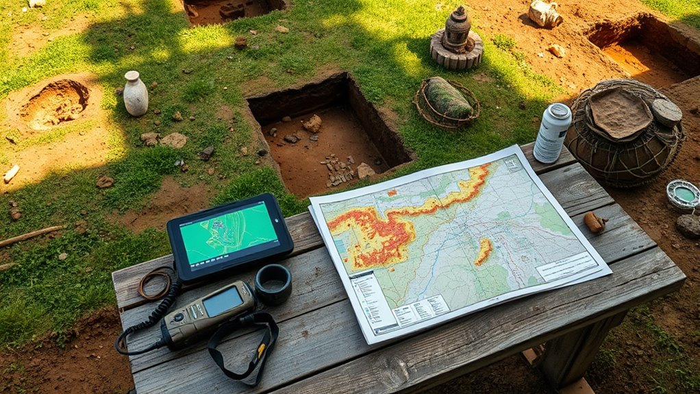
Mapping archaeological finds has become more accessible than ever thanks to open-source tools. This revolution in technology puts the power directly into your hands, enabling you to chart discoveries with unprecedented precision and confidence. No longer do you need expensive software or specialized training; instead, you can leverage free GPS and GIS platforms to document and share your findings. This shift democratizes archaeology, empowering you to take control of your work and contribute meaningfully to a collective understanding of our history.
Open-source tools empower anyone to map archaeological discoveries with confidence and precision.
When you use open-source GPS tools, you benefit from improved data accuracy. These tools allow you to record the exact location of artifacts, features, and sites with pinpoint precision. Accurate data isn’t just about numbers — it’s about ensuring your discoveries can be reliably integrated into broader research or protected for future generations. With open-source GIS, you can layer your data over maps, analyze spatial relationships, and identify patterns that might otherwise go unnoticed. This level of detail enhances both your personal understanding and the quality of the community’s collective knowledge. Additionally, these tools support community resilience, encouraging collaborative efforts in heritage preservation.
But technology isn’t the only game-changer here. Engaging your community becomes a crucial part of this process. When you share your mapped finds through open-source platforms, you foster a sense of shared ownership and pride. Community engagement transforms archaeology from a distant, academic pursuit into a grassroots movement. Local communities can participate actively, providing insights, stories, and context that enrich the data. This participatory approach not only increases data richness but also promotes a sense of liberation from traditional gatekeeping roles. Everyone becomes a steward of their heritage, working together to preserve and understand their history.
Open-source tools also make it easier to democratize access. You don’t need a university or government backing to contribute. Whether you’re a hobbyist, a student, or a seasoned archaeologist, you can use these platforms to document your discoveries and connect with others. Sharing your maps and data openly invites collaboration and transparency, breaking down barriers that once kept knowledge confined to a select few. This collective effort strengthens the community’s voice, making archaeology more inclusive, more dynamic, and ultimately more emancipated from the constraints of proprietary technology.
In the end, mapping archaeological finds with open-source GPS and GIS tools isn’t just about collecting data—it’s about reclaiming your agency. It’s about ensuring your discoveries are accurate, meaningful, and accessible to all. When you harness these tools, you’re not just an observer—you become a crucial part of a movement that values transparency, collaboration, and the liberation of knowledge. Your work helps build a future where history belongs to everyone, and every find contributes to a richer, more inclusive story.
Frequently Asked Questions
What Are the Best Open-Source GPS Apps for Beginners?
You’ll love OsmAnd and Maps.me for open-source GPS apps. They feature user-friendly interfaces that make navigation easy, even for beginners. Plus, their offline capabilities let you explore freely without internet, giving you the freedom to wander without restrictions. These apps empower you to take control of your adventures, offering reliable tools that don’t tie you down to proprietary systems. Embrace independence and explore the world on your own terms.
How Can I Ensure Data Privacy When Using Open-Source Mapping Tools?
Imagine you’re the hero in your own digital freedom story. To safeguard your privacy with open-source mapping tools, activate data encryption and limit user access. Always choose apps that prioritize privacy and avoid sharing sensitive info. Keep your software updated and use strong passwords. By taking control, you guarantee your data stays private, empowering you to explore freely without fear of surveillance or data misuse.
Are Open-Source GIS Tools Suitable for Professional Archaeological Research?
Yes, open-source GIS tools are suitable for professional archaeological research. They empower you to analyze historical data with precision and flexibility, free from proprietary constraints. Plus, community support keeps you connected, allowing you to customize your workflows and solve problems collaboratively. This liberation from closed systems guarantees you harness powerful tools, fostering innovation and discovery in your archaeological endeavors.
What Hardware Is Recommended for High-Precision Open-Source Mapping?
A stitch in time saves nine, and for high-precision mapping, choosing the right hardware is key. You should opt for a reliable GNSS receiver with sensor calibration features and robust data synchronization capabilities. Pair it with a durable, high-quality tablet or laptop for real-time data processing. This setup liberates you from constraints, ensuring your archaeological work is accurate, efficient, and fully in your control.
How Do Open-Source Mapping Tools Compare With Commercial Alternatives?
Open-source mapping tools often match commercial alternatives in mapping accuracy, giving you the freedom to customize and improve your projects without restrictions. Their user interface can be intuitive, empowering you to learn and adapt quickly. You gain control over your data and workflows, liberating you from vendor lock-in. With open-source options, you’re free to innovate, share, and grow your mapping capabilities on your terms, fostering independence and creativity.
Conclusion
By embracing open-source tools, you can map with confidence, explore with curiosity, and analyze with accuracy. These tools empower you to uncover insights, share discoveries, and improve understanding—all while saving costs and fostering collaboration. With open-source resources, you’re not just mapping; you’re connecting, creating, and contributing to a global community. So, immerse yourself, experiment, and let open-source mapping open new horizons for your projects and passions.